基本信息
以下是所在类或对象的基本信息。
AMD:
require(["esri/views/MapView"], (MapView) => { /* code goes here */ });
ESM:
import MapView from "@arcgis/core/views/MapView";
类:
esri/views/MapView
自从:用于 JavaScript 4.0 的 ArcGIS API
用法说明
概述
MapView 显示 Map 实例的 2D 视图。必须创建 MapView 的实例以在 2D 中渲染 Map(及其操作层和基础层)。要以 3D 形式渲染Map及其图层,请参阅 SceneView 的文档。有关视图的一般概述,请参阅View。
对于用户在 DOM 中可见的Map,必须创建 MapView 表示至少两个对象:Map 实例和 DOM 元素。每个分别在Map和容器属性中设置。
// Create a MapView instance (for 2D viewing)
const view = new MapView({
  map: myMap,  // References a Map instance
  container: "viewDiv"  // References the ID of a DOM element
});
使用视图
除了负责Map 及其元素的渲染之外,MapView 还处理用户与Map之间的交互。例如,传统Map比例尺未设置在 Map 上;它设置在 MapView 上。
view.scale = 24000; // Sets a 1:24,0000 scale on the view
MapView 在构建后可能无法立即准备好显示。例如,可能需要首先加载Map数据以确定视图的空间参考,或者 DOM 容器可能尚未具有非零大小。许多视图方法(例如 hitTest 或 goTo)需要视图准备好才能使用。
可以调用MapView 实例上的.when() 方法来执行只能在Map加载后运行的进程。
view.when(function() {
  // MapView is now ready for display and can be used. Here we will
  // use goTo to view a particular location at a given zoom level and center
  view.goTo({
    center: [-112, 38],
    zoom: 12
  });
})
.catch(function(err) {
  // A rejected view indicates a fatal error making it unable to display.
  // Use the errback function to handle when the view doesn't load properly
  console.error("MapView rejected:", err);
});
有关 view.when() 的实时示例,请参阅如何使用 Add 2D overview map in SceneView 示例。
程序化导航
您可以通过使用中心和比例或缩放的组合,或者通过在 MapView 的构造函数中设置范围或视点属性来设置初始范围(或Map的可见部分)。
由于某些视图属性会相互覆盖,因此在构建视图期间应用这些属性时会存在一组优先级。初始化时,MapView 需要一个中心和比例,以及可选的旋转。中心和比例源自多个属性:中心、缩放、比例、范围或视点。 center 和 scale 都可以从 extent 和 viewpoint 派生。如果在构造函数中设置了所有属性,则它们将按照定义的顺序应用。例如,比例是从范围派生的,因此在范围之后设置比例会覆盖派生值,而从范围中心派生的中心保持不变。下表说明了哪些属性在视图构造期间具有优先级(被覆盖的属性在构造期间不会产生任何影响)。
| 属性 | 覆盖 |
|---|---|
| viewpoint | 范围、中心、比例、缩放 |
| extent | 中心、比例、缩放 |
const view = new MapView({
  map: map,
  container: "viewDiv",
  zoom: 10,
  extent: initialExtent, // will override zoom
  // map will be centered at [0,0], but the scale from initialExtent will be used
  center: [0,0]
});
注意
- 如果构造函数中设置的中心、范围或viewpoint.targetGeometry的空间参考与视图的spatialReference不匹配,则将动态加载projection engine。
- 在运行时,当将中心、范围或视点设置为与视图空间参考不匹配的空间参考时,projection engine 必须为 loaded。您可以在设置这些属性之前通过调用 projection.isLoaded() 检查投影引擎是否已加载。如果尚未加载,您可以调用projection.load()。
// Create a map with Antarctic imagery basemap
const map = new Map({
  basemap: new Basemap({
    portalItem: {
      id: "6553466517dd4d5e8b0c518b8d6b64cb" // Antarctic Imagery
    }
  });
});

// Set the center and zoom level on the view.
// In this case, the view's spatial reference wkid is 3031
// center is lat/long. Projection engine will be loaded dynamically
// to project the center to match the spatial reference of the view
const view = new MapView({
  map: map,  // References a Map instance
  container: "viewDiv"  // References the ID of a DOM element
  center: [-100, 35], // Sets the center point of the view at a specified lon/lat
  zoom: 3 // MapView converts this to its corresponding scale which is 112823780.660964
});
// Sets the center point of the view at a specified lon/lat
view.center = [-112, 38];
view.zoom = 13;  // Sets the zoom LOD to 13

// new extent for the mapview where the spatialReference.wkid is 4326
const extent = new Extent({
  xmin: -9177882,
  ymin: 4246761,
  xmax: -9176720,
  ymax: 4247967,
  spatialReference: {
    wkid: 102100
  }
});

if (!projection.isLoaded()) {
  // load the projection engine if it is not loaded
  await projection.load();
}
view.extent = extent;
由于 View 处理用户交互,因此单击等事件是在 MapView 上处理的。使用 goTo() 方法也可以实现动画,该方法允许您将 MapView 从一个范围更改或移动到另一个范围。
缩放和 LOD
为什么设置MapView.zoom总是不起作用,为什么它的值是-1?本节介绍 MapView 缩放和 LOD 的工作原理。Map的 basemap 定义加载视图时 MapView 的有效 LOD。 LOD 具有 scale 和相应的 zoom 值,可用于导航Map。如果MapView具有有效的有效LOD,则可以在MapView上设置缩放值。在这种情况下,视图将其转换为相应的比例,或者如果缩放是小数,则对其进行插值。
如果以下陈述成立,则 MapView 的 constraints.effectiveLODs 将是 null:
如果有效LOD 为null,则无法在MapView 上设置zoom,因为无法进行转换。在这种情况下,缩放值将为-1。设置比例就可以了。为了解决这个问题,可以在初始化时通过调用 TileInfo.create().lods 来定义 MapView 的 constraints.lods 。
const layer = new FeatureLayer({
  url: "https://services.arcgis.com/P3ePLMYs2RVChkJx/ArcGIS/rest/services/World_Countries_(Generalized)/FeatureServer/0"
});

// initialize the map without basemap, just add the feature layer to the map
// feature layer does not have tileInfo to derive effectiveLODs from
const map = new Map({
  layers: [layer]
});

// Create a tileInfo instance using the default settings and pass its
// resulting LODs to a MapView's constraints.lods.
const view = new MapView({
  container: "viewDiv",
  map: map,
  zoom: 3, // this will work because we are creating LODs. Otherwise, it will not work
  constraints: {
    lods: TileInfo.create({
      // create the LODs to match the spatial reference of the view
      spatialReference: viewSpatialReference
    }).lods
  },
  spatialReference: viewSpatialReference
});
MapView 导航
MapView 导航默认启用,包括鼠标交互,如下表所述。
| 行动 | MapView 行为 |
|---|---|
| Drag | Pan |
| Double-click | 放大光标 |
| Ctrl+双击 | 缩小光标处 |
| 向前滚动 | 放大光标 |
| 向后滚动 | 缩小光标处 |
| 右键单击+拖动 | 2D-rotate |
| Shift+左键单击+拖动 | 缩放到绘制图形的范围 |
| 方向键 | 向左、向右、向上或向下微移视图 |
| N | 调整视图指向北方 |
| A | 逆时针旋转视图 |
| D | 顺时针旋转视图 |
| + | 在Map中心逐渐放大 |
| - | 在Map中心逐渐缩小 |
| 用一根或多根手指拖动 | Pan |
| Double-tap 用一根手指缩放 | 在手指位置平移 |
| 两指捏入/捏出 | 缩小/放大 |
| 顺时针或逆时针方向移动两根手指 | Rotate |
要禁用MapView 导航,您必须对触发导航的指针或手势事件的事件对象调用stopPropagation() 方法。
有关示例,请参阅我们在 disabling view navigation 上的示例。
MapView 使用游戏手柄和 3DConnexion 设备进行导航
当 view.navigation.gamepad.enabled 设置为 true(默认)时,游戏手柄和 3Dconnexion 设备(如 SpaceMouse)可用于导航。要在 MapView 中启用缩放,必须将 view.constraints.snapToZoom 设置为 false(默认为 true )。请参阅GamepadInputDevice 了解支持的设备。
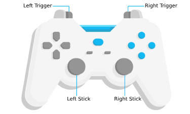
| 游戏手柄动作 | MapView 行为 |
|---|---|
| 左触发器 | 放大 |
| 右触发器 | 缩小 |
| 左摇杆 | 平移视图 |
| 右摇杆 | 旋转视图 |
| 动作形象 | SpaceMouse 动作 | MapView 行为 |
|---|---|---|
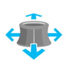 |
推(左/右/前/后) | 平移视图 |
 |
拉起 | 缩小 |
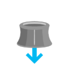 |
向下推 | 放大 |
 |
顺时针旋转 | 顺时针旋转视图 |
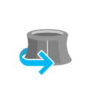 |
逆时针旋转 | 逆时针旋转视图 |
要禁用游戏手柄导航,您可以将 view.navigation.gamepad.enabled 设置为 false 。
注意:
- 缩放捕捉必须禁用连续缩放。在Map视图中,
snapToZoom是true默认。view.constraints.snapToZoom = false;
- 根据 W3C Working Draft 29 October 2020 ,如果 Web 应用程序托管在 non-secure context(例如 http 而不是 https)上,则游戏手柄函数可能无法在部分或所有浏览器上使用。用于 JavaScript 的 ArcGIS API 的未来版本可能会在非安全上下文中显式禁用游戏手柄函数。
处理事件
当用户与 MapView 交互时,他们的操作会触发您可以侦听和响应的事件。例如,您可以监听用户将鼠标移到Map上并显示鼠标位置的坐标。这称为pointer-move 事件。有关所有事件的列表,请参阅MapView 事件部分。
请务必注意,某些事件是相互依赖的,并且用户交互的时间可能会影响触发的事件类型。例如,单击一次会触发一系列事件:当用户按下鼠标按钮时pointer-down,当用户释放鼠标按钮时pointer-up。 immediate-click 事件在 pointer-up 事件之后立即触发。 immediate-click 应用于立即响应用户交互。只有在确保用户不会再次单击后才会触发单击事件(在这种情况下会触发双击事件)。
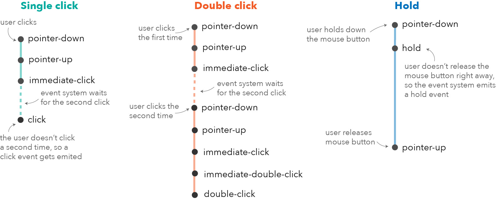
如果是双击,则在第一次单击后会重复相同的事件链。但是,如果用户在接近的时间范围内第二次单击,则不再发出单击事件,但会再次触发 pointer-down、pointer-up 和 immediate-click 事件。在两个 immediate-click 事件之后,双击事件会与 immediate-double-click 事件一起触发。两者之间的区别在于,immediate-double-click 无法通过在 immediate-click 事件上使用 stopPropagation 来阻止,因此可用于对 double-clicking 做出反应,而与 immediate-click 事件的使用无关。
这些事件也在内部用于导航、弹出窗口或不同的交互工具,如测量或草图。在某些用例中,添加额外的事件侦听器可能会干扰默认事件侦听器。例如,添加immediate-click 事件来打开一个弹出窗口,将干扰同样打开一个弹出窗口的默认 click 事件。
请参阅Event explorer 示例,以可视化与视图交互时触发的不同事件。
相关用法
- JavaScript ArcGIS MapView double-click事件用法及代码示例
- JavaScript ArcGIS MapView.constraints用法及代码示例
- JavaScript ArcGIS MapView.takeScreenshot用法及代码示例
- JavaScript ArcGIS MapView.when用法及代码示例
- JavaScript ArcGIS MapView.highlightOptions用法及代码示例
- JavaScript ArcGIS MapView layerview-create事件用法及代码示例
- JavaScript ArcGIS MapView.extent用法及代码示例
- JavaScript ArcGIS MapView.whenLayerView用法及代码示例
- JavaScript ArcGIS MapView click事件用法及代码示例
- JavaScript ArcGIS MapView.scale用法及代码示例
- JavaScript ArcGIS MapView pointer-move事件用法及代码示例
- JavaScript ArcGIS MapView.toScreen用法及代码示例
- JavaScript ArcGIS MapView.navigation用法及代码示例
- JavaScript ArcGIS MapView.animation用法及代码示例
- JavaScript ArcGIS MapView.widthBreakpoint用法及代码示例
- JavaScript ArcGIS MapView.input用法及代码示例
- JavaScript ArcGIS MapView.fatalError用法及代码示例
- JavaScript ArcGIS MapView.hitTest用法及代码示例
- JavaScript ArcGIS MapView.destroy用法及代码示例
- JavaScript ArcGIS MapView.background用法及代码示例
- JavaScript ArcGIS MapView.spatialReference用法及代码示例
- JavaScript ArcGIS MapView.breakpoints用法及代码示例
- JavaScript ArcGIS MapView.tryFatalErrorRecovery用法及代码示例
- JavaScript ArcGIS MapView layerview-create-error事件用法及代码示例
- JavaScript ArcGIS MapView hold事件用法及代码示例
注:本文由纯净天空筛选整理自arcgis.com大神的英文原创作品 MapView。非经特殊声明,原始代码版权归原作者所有,本译文未经允许或授权,请勿转载或复制。